Monitoring network
The water board manages approximately 1,500 km of dikes. TheWater Safety 2030 programme was established to ensure we have a clear understanding of how strong and safe these dikes are. This programme that we have a continuous overview of the condition of our dikes and the flood risks.
An important factor in the safety of a dike is the groundwater level within it. If this level is too high or too low, a dike can weaken or become unsafe. To properly monitor groundwater levels in our dikes and gain insight into them, we have established a groundwater monitoring network. This network allows us to measure groundwater levels within dikes.
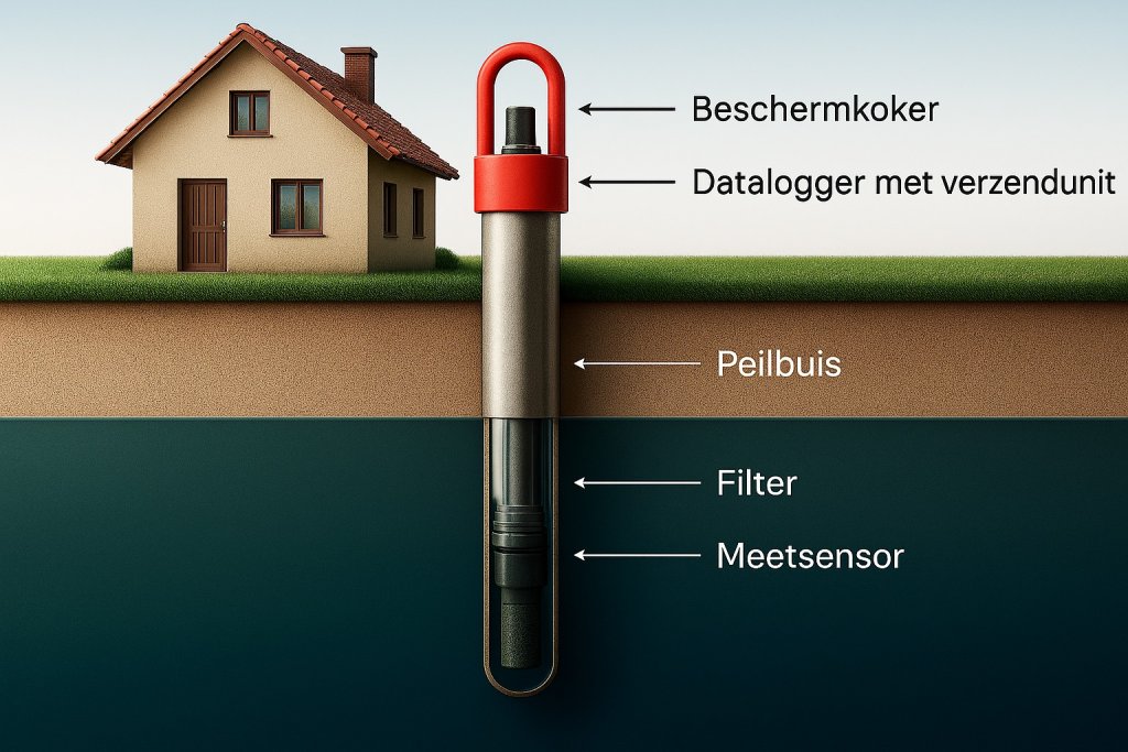
This monitoring network consists of an extensive network of monitoring wells spread throughout our entire management area. Each monitoring well has:
- a sensor in the ground that measures the groundwater level;
- a sleeve that protects the monitoring well;
- a data logger with a transmitter that automatically sends the data to HHNK.
Below is a schematic diagram of a monitoring well.
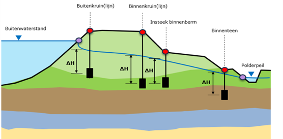
Monitoring wells are often installed in clusters—groups of three to four wells at different locations across the cross-section of a dike. This allows us to determine the gradient of the groundwater level within the dike (see the blue line in the figure).
To assess the safety of dikes, an evaluation is conducted to determine whether the groundwater level remains within the established limits. A limit value can apply to both excessively high and excessively low groundwater levels. The limits for groundwater levels are determined for each individual dike based on research, statistics, and calculations.
The monitoring network allows us to detect in a timely manner when the groundwater level becomes too high or too low, and to take any necessary measures to ensure the safety of the dike.
Automatic groundwater level monitoring aligns well with the HHNK 2050+ Vision. In the future , dikes will also face system limits more frequently, partly due to climate change and more extreme precipitation. As precipitation changes in both intensity and volume in the future, the groundwater level within the dikes will also change.
Our monitoring network allows us to measure these changes in groundwater levels. This enables us to anticipate changing conditions and ensure that our flood defenses remain safe well into the future!