Improvement of wet infrastructure in Noordkop
This project (known as Noordkop for short) will improve fish migration and increase the diversity of fish species between the Wadden Sea, the IJsselmeer, and the North Holland hinterland that lies between them. It will also lead to more diverse habitats for fish.
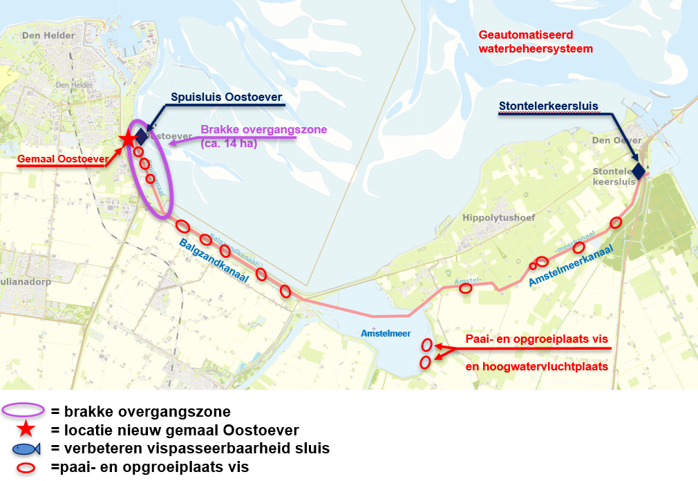
The Noordkop project focuses on the Amstelmeerboezem between the Spuisluis Oostoever near Den Helder and the Stontelerkeersluis near the IJsselmeer. The measures we are taking not only improve fish migration and diversity, but also contribute to a future-proof water management system. In other words, the measures will help to properly regulate the increasing amount of water in the area in the coming years. A future-proof water management system is of great importance for water safety in the future.
What's going to happen?
Along the Wadden Sea coast, the transition from salt to fresh water to the hinterland is quite abrupt. For many fish species, a gradual transition is important. This concerns partly fish that migrate between the Wadden Sea and the IJsselmeer and partly fish that thrive better in brackish water (a combination of fresh and salt water). In the Noordkop project, we are solving this by creating an approximately 14-hectare brackish transition zone in the Spuikanaal near Oostoever. This is only possible if we can properly control the amount of salt water flowing in. Too much salt water has a negative effect on agriculture, among other things, which depends on fresh water.
Controlled, tide-driven inflow and outflow of water through the Oostoever fish passage, supported by measures such as a pumping station, continuous salt measurements, a bottom threshold, and an automatic control system, allows for a more natural inflow and outflow of salt and fresh water in the westernmost part of the Amstelmeer basin. This prevents the freshwater supply for agriculture from being negatively affected via the inlet points south of the Amstelmeer and at the Amstelmeer Canal. In addition, we are making it easier for fish to pass through the Stontelerkeersluis by constructing a fish passage. We are also creating spawning and rearing areas for fish in the Amstelmeerboezem and high-water refuges for birds in the Amstelmeer.
Improving fish migration
The proposed package of measures will create a more natural brackish transition zone of approximately 14 hectares behind the Oostoever sluice. Such gradual transition zones are rare in the Netherlands, especially on this scale. The measures will benefit both tidal migrants, fish that use the rising tide to enter the polder, and migratory fish species that need a gradual transition to acclimatize. The brackish transition zone is also important for estuarine fish species that live in the brackish transition zone all year round. It is precisely these three groups that are currently almost completely absent. The area functions as both a habitat and a corridor between the Wadden Sea, the Amstelmeerboezem, the IJsselmeer, and the North Holland hinterland.
Curious about the life cycle of these fish? The “Ruim baan voor Vissen” knowledge base offers detailed information on more than just the target species of this project.
Future-proofing the Amstelmeerboezem
The measures, and in particular the pumping station, also ensure that the Amstelmeerboezem is prepared for the expected rise in sea level and climate change. The Amstelmeerboezem drains a total area of approximately 23,000 ha via eleven polder pumping stations and via the De Waakzaamheid pumping station from the VRNK drainage basin. The Amstelmeerboezem drains into the Wadden Sea via a sluice at Oostoever. In the current situation, there is no drainage pumping station that pumps out water. However, sea level rise will reduce the possibility of drainage in the future. At the same time, the amount of water to be drained will increase due to more and more intense precipitation. Both mechanisms increase the risk of flooding. The package of measures will combat not only flooding but also salinization. At present, relatively brackish water is occasionally discharged from the Balgzand Canal to the fresh Schermer reservoir when insufficient water can be discharged via the sluice gate (as will be the case in the fall of 2023, for example). The pumping station will greatly reduce this. This is important for growers in the Koegraspolder and Anna Paulownapolder, among others, who use this reservoir water. The automated water management system also provides better control options, allowing for more economical use of (fresh) water.
Planning
The Noordkop project is divided into three phases: exploration, plan development, and implementation. Most of the measures in the project are currently in the implementation phase. In this phase, work is being done on the implementation of the measures.
In August 2025, Beentjes GWW began constructing fish spawning and nursery areas in the Amstelmeerboezem. The work is being carried out on the reed banks of the Spuikanaal, Balgzandkanaal, Amstelmeerkanaal, and the outer basin near the Stontelerkeersluis and is expected to be completed in 2026.
The Stontelerkeersluis fish passage was awarded to contractor K. Dekker at the end of 2025. Preparations for the project have already begun, so that work can start in early 2026. The project is expected to be completed in 2026.
The Oostoever pumping station is the final part of the project to be implemented. The contract for further development and implementation was awarded to Van Hattum en Blankevoort at the end of 2025. The pumping station was designed by architectural firm KBNG. Implementation is scheduled to start inthe second half of 2026.
Permits
All permits have been successfully granted.
Who are we working with and who is helping to make this project possible?
The following parties are financing the 'Improvement of Wet Infrastructure in Noordkop' project: the Wadden Fund, the province of North Holland, and the Ministry of Infrastructure and Water Management. We therefore work closely with these parties, and coordination and accountability for the projects towards these financiers is crucial. Within the project, there is contact with stakeholders such as the municipalities, the Land and Horticulture Organization, Landschap Noord-Holland, and the professional and recreational fishing sectors.
The Noordkop project is part of Ruim Baan voor Vissen 2 (Make Way for Fish 2): a collaboration between the four northern water boards, Van Hall Larenstein, and the Wadden Fund. This collaboration aims to improve fish migration routes and restore the ecological relationship between the Wadden Sea and the hinterland.
Measures explained in more detail
East Bank Pumping Station
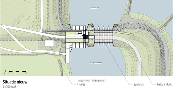
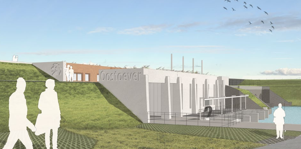
The new Oostoever pumping station plays an important role in controlling chloride levels and contributes to climate adaptation in the Amstelmeerboezem. Water is discharged into the Wadden Sea via the sluice gate as much as possible; the pumping station is used when discharge is insufficiently effective. The new pumping station will be located west of the existing sluice gate. The current Oostoever sluice gate will therefore be retained. The drawing below shows a top view of the architectural design, with the new pumping station complex as the western part (white) and the existing sluice pipes of the sluice gate as the eastern part (grey). The existing water level house will be retained.
No modifications will be made to the sluice gate and the flood barrier to the east of the complex. The current sluice gates will continue to be used, with the pumps serving as a supplement and being deployed when necessary. The pumping station will become part of the primary flood barrier and will comply with the relevant safety standards.
The inflow and outflow width on both the Wadden Sea and Balgzand sides will be increased. The 't Kuitje nature education center will be retained. The HHNK bulkhead shed and the reserve sluice gates of the drainage sluice will be removed.
Fish passage East Bank
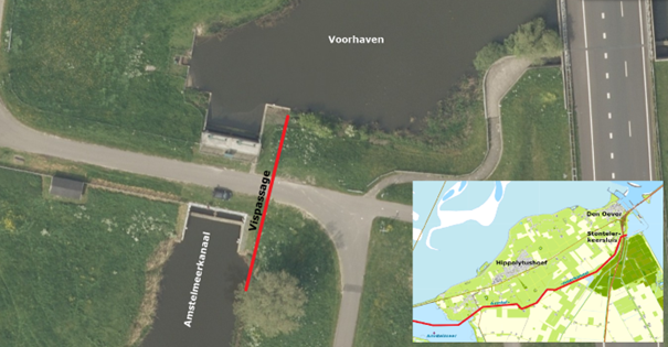
On the east side of the pumping station complex, there will be a tidal vertical-slot fish passage between the Wadden Sea and the Balgzand Canal. This is a concrete migration channel with vertical partitions and a tube through the flood barrier that can be closed on both sides with sluice gates.
There is currently a relatively high leakage flow at the sluices from the Wadden Sea to the Spuikanaal. This is largely caused by uncovered openings above the sluice gates of the Spuisluis. Fish migration through these openings is virtually impossible. In the new situation, the uncontrolled inflow of seawater through these openings in the Oostoever sluice will be replaced by a controlled and manageable system. To this end, the aforementioned openings in the sluice will be closed and a lockable fish passage will be installed as part of the new Oostoever pumping station. In addition to its fish migration function, this fish passage also serves as an inlet and outlet for inland and seawater: at high water levels, water flows from the Wadden Sea into the Balgzand Canal, and at low water levels, (brackish) water flows from the Spuikanaal back to the Wadden Sea. The fish passage does not have a water level regulating function. The design has been developed in such a way that the passage can be sufficiently open for fish without increasing the salt load too much. Management is adaptive, allowing settings to be adjusted per season and the fish passage to be completely closed in critical situations to prevent salinization.
Saltwater barrier and salt management
Fish can migrate via the Oostoever fish passage, but at the same time, this fish passage also allows salt water to flow in and out. This salt must not threaten the supply of fresh water to the polders and must therefore remain easily controllable. The original plan included a saltwater barrier at the Kooybrug. During the webinar, we explained that research was still ongoing to determine which model would be most suitable. Various construction options, such as fixed or movable barriers and bubble screens, were considered. This research showed that these solutions were neither effective nor desirable. In addition, the research into salt control indicated that a natural soil threshold at the Balgbrug bridge contributes significantly to a stable salt balance (natural saltwater barrier) and that the sluice and pumping station also have a major influence on salt control. Therefore, the planned structural saltwater barrier at the Kooijsluis has been abandoned in favor of preserving the soil threshold, combined with targeted sluice management and the use of the pumping station. In the event of an increase in the salt content of the water, we have various measures in place to keep salt management under control:
- First, we close the fish passage in the pumping station.
- We can then discharge the salt water into the Wadden Sea.
- If that is not possible or insufficient, we pump away the salt water with the pumping station.
- And when that is not enough—for example, in times of drought—we can bring in extra fresh water from the IJsselmeer via the Stontelerkeersluis.
This approach allows us to keep the salinity level under control and ensure a good balance between fish migration, nature, and the availability of fresh water in the Noordkop region.
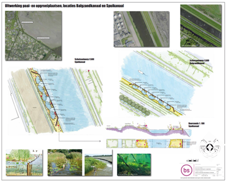
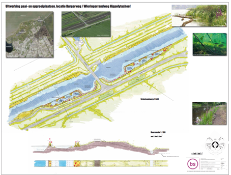
Fish spawning and nursery areas
To give migratory fish a good place to spawn (lay eggs) and grow, we are creating new habitats. These connect to the gradual transition from fresh to salt water. In this transition zone and in the channels behind the Amstelmeer, quiet, sheltered spots, known as fish spawning and nursery areas, are being created in the water so that fish can hide there. We kilometre these spawning and nursery areas over a length of 16.5 kilometre : on average, one per 250 metre. Together, these areas cover a surface area of approximately 2.15 hectares.
The work mainly consists of digging out silted banks and installing sheet piling. Most locations were completed from pontoons in the water. This creates sheltered areas: pools of varying depths that protect young fish from being washed away and serve as resting and spawning places for all fish.
Fish passage Stontelerkeersluis
The Stontelerkeersluis lock is the gateway for fish from the IJsselmeer to the Amstelmeerboezem. Unfortunately, the current lock is not passable for fish. The construction of a fish passage will also open up the Amstelmeerboezem to fish via the IJsselmeer. This will allow fish to make even better use of the area and will also enable fish that enter the IJsselmeer via the Afsluitdijk (including VMR) to use the area. In addition, fish entering at Oostoever and migrating over long distances will be able to reach the IJsselmeer.
For more information, see the page Construction of fish passage at Stontelerkeersluis.
Webinar
On June 24, 2024, we organized an informative webinar about the project.
The questions most frequently asked during the webinar and the corresponding answers can be found on the Noordkop webinar FAQ page.
Want to know more?
For more information about this project, please contact us via ourcontact formor by calling072 582 8282.