
Drought 2026: Questions and Answers
On this page, you can find answers to any questions you may have about the drought situation in our management area.
For the latest updates, check out our live blog.
Drought in General
Where can I track the drought?
Through our live blog atwww.hhnk.nl, we’ll keep you updated on the drought situation in Hollands Noorderkwartier.
You can check the national drought monitor at every day.
What is a precipitation deficit?
A precipitation deficit is the difference between expected evaporation and measured precipitation. When calculating a precipitation deficit or surplus, all water boards use the agricultural calendar, which begins on April 1. At that point, we reset the counter to zero. From then on, it’s a matter of adding and subtracting. We add every millimeter of precipitation and subtract every millimeter of evaporation. The result of that calculation indicates a precipitation deficit or surplus. On dry days, surface water evaporates and the land dries out. On a long, warm, sunny summer day, about 5 millimeters evaporate per 24-hour period. The sun is high in the sky then and has a greater impact. In early spring and fall, evaporation is much lower.
What are the consequences of a precipitation deficit?
Dikes are made of various types of soil, such as clay, sand, and sometimes peat. A good dike is a damp one. Rain nourishes a dike. During a long, dry period, dikes may develop cracks. Because water sometimes seeps in through these cracks, wet (weaker) spots can form on the dike. Dikes that dry out may become less strong.
During a dry spell, water evaporates—not only from the ditch, but also from the fields. This has consequences for farmers, for our gardens, for nature, and also for the life in the ditch.
When the water in the ditch warms up, blue-green algae bloom, reducing the oxygen levels in the water and putting fish at risk of suffocation.
Because we in Hollands Noorderkwartier live largely on what was once the seabed, the soil is relatively salty. Sufficient fresh water in our ditches prevents this salt from seeping upward. During periods of drought, the soil and ditches can become salinated. The salinity in ditches and ponds then increases. This is harmful to agriculture and nature.
What does the water board do during a drought?
Normally, the water board uses pumping stations to discharge excess water from our low-lying service area into the IJsselmeer and Markermeer. That’s not necessary right now. In fact, there’s actually a greater need for water than what’s falling from the sky.
The water board is leaving locks or weirs slightly open at numerous locations along the IJsselmeer and Markermeer. This allows water to flow into the Noorderkwartier through our extensive network of ditches. The base of the dikes remains supplied with water, the ditches stay at the proper level, the ditch water is refreshed slightly, and farmers can use the ditch water for their crops.
As the precipitation deficit increases, our field staff closely monitor the condition of the dikes. We start with the dikes most vulnerable to drought, which are partly composed of peat. These dikes are more susceptible to drying out than those built entirely of clay. When the precipitation deficit reaches 225 millimeters, we assess whether concrete measures are necessary. We then decide whether our inspectors should go out to inspect our drought-sensitive dikes. This has happened recently. Approximately 65 kilometre dikes were inspected. Drones can also be used to detect cracks. When the precipitation deficit reaches 275 millimeters, approximately 495 kilometre are inspected. This allows us to identify drought-related damage to our dikes—such as cracks, wet spots, deformation, and dried-out grass—in a timely manner. If necessary, measures are taken or the dikes are monitored more closely. This is how we ensure safe dikes and keep residents’ feet dry.
What is a water shortage?
A water shortage is different from a precipitation shortage, but it also contributes to the overall drought. A water shortage means that the demand for water (for example, from the agricultural sector or industry) exceeds the supply. Currently, there is no water shortage, because the inflow from the rivers into the Markermeer and IJsselmeer is still sufficient to allow us to draw enough water from those lakes into our region. This enables us to meet the demand for water at this time.
Nevertheless, the area is very dry due to the lack of rainfall.
What are other water districts doing to combat drought?
The Union of Water Boards maintains a blog that tracks the measures being taken by other water boards:Drought: The Current Situation.
How does HHNK ensure there is water in the ditch when it doesn't rain?
We draw water from the IJsselmeer and Markermeer at various locations. The water we draw in is distributed throughout our area via an advanced system of ditches, weirs, and pumping stations. This ensures that our ditches and canals have an adequate supply of clean water.
Why is evening watering recommended?
In the evening, temperatures are lower and there is less evaporation.
Why was the HHNK crisis response team expanded?
Due to the ongoing drought, the nationwide escalation to “de facto water shortage” / Phase 2, and preparations for measures that may be required, HHNK is escalating to Alert Phase 2. This will enable us to implement the measures we are currently preparing more quickly if necessary.
Dikes
When will the water board inspect the dikes?
As the precipitation deficit increases, our field staff closely monitor the condition of the dikes. We start with the dikes most susceptible to drought, which are partly composed of peat. These dikes are more susceptible to drying out than those made entirely of clay.
If the precipitation deficit exceeds 225 mm, we will consider conducting on-site inspections of the dikes. In that case, approximately 65, kilometre s of drought-sensitive dikes will be inspected first. This was done in July by HHNK. These dikes are located primarily in the Waterland region. They are very old dikes, often with a peat core and a clay cap.
Due to the ongoing drought, other dikes have also been identified for inspection. Starting Wednesday, August 12, HHNK will inspect 400 km of drought-sensitive dikes. This will ensure that drought-related damage to our dikes (such as cracks, wet spots, deformation, and dried-out grass) is identified in a timely manner. If necessary, measures will be taken or the dikes will be monitored more closely. This is a precautionary measure based on the precipitation deficit and the forecast. At this time, the dikes are stable. In this way, we ensure safe dikes and keep residents’ feet dry.
How does the water board inspect the dikes?
Our area managers and maintenance staff conduct inspections in pairs. We also use drones to detect and monitor cracks. This is only possible if cracks are visible from above, when there is no tall grass or mowed grass on the dike. We use monitoring wells to measure the groundwater level in the dike, so we know how dry it is inside the dike itself.
Does HHNK have peat dikes?
We do not have any dikes made entirely of peat. Some dikes do, however, contain a historical peat core. These are covered with clay and are further filled with clay during reinforcement.
No new peat dikes are being built these days. When we reinforce a dike, we use clay and other suitable soil types. As a result, the proportion of peat in our flood defenses is gradually decreasing.
Does HHNK keep the dikes wet?
We do not actively keep our dikes wet. This is not necessary due to the structure of our dikes. We do not have dikes made entirely of peat. Some dikes contain a historical peat core, which is encased in a thick layer of clay. In addition, severely dried-out soil does not always absorb water immediately. This is similar to dried-out soil in a flowerpot, where water can initially run off the dry soil.
Can grass be mowed on dikes during a drought?
Yes, mowing can be beneficial for a dike even during a drought. By mowing sparingly and carefully, the grass remains healthy, strong, and even. Slightly longer grass also provides shade for the soil, which slows down moisture evaporation. Stopping mowing entirely isn’t always wise. If the grass is still growing and green, a light mowing helps keep the turf strong. This allows the grass to recover more effectively as soon as more moisture becomes available.
Locks
Why does the water board let water in?
Normally, excess water in the low-lying areas of North Holland is drained through ditches to the pumping stations, so that our feet stay dry. Because of the drought, we’re now letting water in, because otherwise our feet would be too dry. Water in the ditches is necessary for many reasons. A lower water level in the ditches means farmers have less water available to irrigate their crops—especially since it’s currently the growing season. A lower water level also causes the adjacent land to dry out more easily. Furthermore, the ditches then contain less oxygen and warm up more quickly, which has major consequences for plants and animals. The banks of ditches that run dry can easily erode. Finally, filled ditches provide counterpressure against saltwater seepage. Without that pressure, saltwater seepage would rise from deeper layers of the earth and cause the land to become saline.
What is the surface water that is discharged into the Hollands Noorderkwartier area used for?
We let water from the IJsselmeer and Markermeer flow in. HHNK ensures that water levels are maintained. This surface water is then abstracted by various users and consumers. We set the water demand for flushing to prevent salinization ourselves, depending on the extent of salt intrusion. We operate on a level-controlled basis and will continue to do so, making adjustments based on water quality and salinization.
| Water Level Maintenance for Water Safety | 5% |
| Water Level Maintenance for Peatland Conservation | 15% |
| Water System Water Level Maintenance | 30% |
| Cooling/process water* | 3% |
| Flushing to Prevent Salinization | 18% |
| Water withdrawal for irrigation | 30% |
* Cooling water is not lost; it flows back into the water system. It is therefore used, but not consumed.
What can I do myself to combat drought?
The drought continues, and the precipitation deficit is increasing in North Holland. As a result, water will become scarce in the short term. HHNK is appealing to all residents and farmers who irrigate their gardens and fields. Deputy Water Board Chair Klazien Hartog: “Irrigating during the day causes a lot of evaporation. To make the available water last longer and be used more sustainably, I urgently call on farmers to irrigate their fields at the end of the day or in the evening; this will prevent additional evaporation. Only by all of us—including residents—using as little surface water as possible can we delay the moment when we run into trouble.”
See the page " What Can You Do Yourself to Combat Drought?"
Grazing Ban
Where does the grazing ban apply?
The grazing ban applies to all dikes along the Wadden Sea in Hollands Noorderkwartier. These include the Wadden Sea Dike on Texel and, on the mainland between Den Helder and Den Oever, the Balgzand Dike, the Amsteldiep Dike, and the dike on Wieringen. A total of sixteen leaseholders are affected by this ban and are not permitted to graze livestock there.
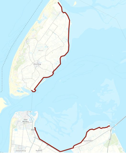
What is a grazing ban?
A grazing ban means that tenants are no longer allowed to let their livestock graze on our dikes.
When does the grazing ban take effect?
Saturday, August 8, at 6:00 p.m.
Why is this ban being imposed?
Due to intensive grazing by livestock combined with the drought, the grass is unable to grow fast enough before the storm season begins. Grass cover needs time to recover. A healthy grass cover is necessary to keep the flood barrier (dike) sturdy. During a storm, when water overflows the dike, the grass cover protects the dike from erosion. By enforcing the grazing ban, we ensure that the dike remains robust and, as a result, the hinterland remains protected this coming winter.
Under normal conditions (when there is no drought), grazing is a common method of maintaining the grass cover on levees.
How long does the grazing ban last?
Once the turf has recovered sufficiently, the ban will be lifted. Healthy turf is necessary to keep the flood barrier (dike) sturdy and thus able to withstand storms.
Are there any dikes where the grazing ban does not apply?
Yes, livestock are still allowed to graze on most dikes in Hollands Noorderkwartier. The grazing ban applies to all dikes along the Wadden Sea. These include the Wadden Sea Dike on Texel and, on the mainland between Den Helder and Den Oever, the Balgzand Dike, the Amsteldiep Dike, and the dike on Wieringen. In total, there are sixteen leaseholders who are not allowed to let their livestock graze there.
Agricultural Advisory Committee and the displacement series
What is the Displacement Series / Water Allocation Strategy?
In the event of an impending water shortage, water is rationed in the Netherlands. The available water is then allocated first to critical needs, such as maintaining our dikes, the drinking water supply, and power plants. Other uses, such as crop irrigation, shipping, and recreation, are given lower priority.
We refer to this (national) prioritization as the “priority sequence.” It specifies which matters take precedence over others in water allocation. Categories 3 and 4 were subsequently elaborated at the regional level by the provinces and water boards in the Water Allocation Strategy. For more information, visit our page: Drought and Water Allocation
Why does the Agricultural Advisory Committee meet?
To prepare for and evaluate each drought season, the Advisory Committee meets twice a year (in April and October) as a matter of routine. It also meets on an ad hoc basis when warranted by current and expected developments—such as now, due to the ongoing drought. Based on current developments, the Advisory Committee can provide the water board with recommendations to minimize the socioeconomic impact of any measures as much as possible. HHNK can take this advice into account when deciding on measures.
Which parties are represented on the Agricultural Advisory Committee?
The Agricultural Advisory Committee includes a broad representation of the agricultural sector. It comprises representatives from the following organizations:
- Dutch Agricultural and Horticultural Organization (LTO)
- Royal General Association for Flower Bulb Cultivation (KAVB)
- Dutch Arable Farming Union (NAV)
- Greenhouse Horticulture in the Netherlands
- Dutch Agricultural Youth Association (HAJK)
- Water, Land & Dikes (WL&D)
- Dutch Dairy Farmers' Union (NMV)
- Dutch Fruit Growers Organization (NFO)
When was the last time the Agriculture Committee met?
The Advisory Committee typically meets twice a year: at the start (April) and at the end of each drought season (October). The Advisory Committee also met in April this year. If circumstances warrant, the Advisory Committee meets more frequently. This has not happened before, but it is now the case. On August 13, the Agricultural Advisory Committee will meet due to the record-high precipitation deficit in Hollands Noorderkwartier and to prepare for the implementation of the water displacement sequence.
What is a ban on flooding?
It is not permitted to withdraw surface water to flood crop fields (inundation). Inundation is the intentional and controlled flooding of fields. Inundation is typically used in agriculture to control, for example, harmful nematodes, fungi, and persistent weeds in the soil.
What does a blanket withdrawal ban entail?
This means that surface water may no longer be withdrawn for the purpose of irrigating or flooding land. This includes agricultural land, as well as sports fields, parks, and public green spaces.
Based on what criteria is a total withdrawal ban decided?
In the event of a water shortage, the Water Allocation Sequence takes effect, which is implemented regionally by HHHNK through the HHNK 2024 Water Allocation Strategy. In the event of an actual water shortage and/or bottlenecks within the HHNK management area, or if the lower limit of the lake level in the IJsselmeer region is reached, a decision will be made to implement measures such as withdrawal bans. The order of measures is set out in the list of measures in the Water Allocation Strategy. The highest priority is given to safety and the prevention of irreversible damage to nature. The second priority is given to critical public utilities (drinking water and energy).
Salinization
What is salinization?
Salinization is the increase in salinity in the soil, groundwater, and surface water. Salinization occurs due to the intrusion of seawater (external); seawater that enters the water system via surface water through, for example, river estuaries, locks, and/or fish passages. In addition, there is internal salinization; salty or brackish groundwater that rises as seepage water and, as a result, enters the soil and the groundwater and surface water.
Salinization occurs in our region along the coast and in areas that used to have brackish or saltwater before they were drained or reclaimed. As a result, the soil contains brackish or saltwater.
How does salinization occur during dry periods?
Because we in Hollands Noorderkwartier live largely on what was once the seabed, the soil is relatively salty. Having enough fresh water in our ditches prevents this salt from seeping upward. During periods of drought, the soil and ditches can become salinated. As soon as there is less fresh water in the ditches, the salty seepage can rise and cause the water in the ditches to become saltier. This is harmful to agriculture and nature.
Shooting Restrictions
What are navigation restrictions?
Lock restrictions are measures that limit lock operations (the movement of vessels between different water levels). By imposing lock restrictions on recreational boating, we ensure that significantly less saltwater flows into the area. Less water is also needed for flushing to combat salinization. This applies, among other places, to the Koopvaardersschutsluis and Boerenverdrietsluis locks in Den Helder, where saltwater and freshwater mix.
Broekermeer Ring Canal
Why is damage occurring now if the dike was previously reinforced?
The previous improvement project on the south side of the Broekermeer involved elevation work. An assessment at the time revealed no stability risks, so no retaining embankment was constructed. Sometimes the subsoil can vary locally, causing damage to become apparent later on. This cannot always be predicted in advance.
Is the dike still safe?
The dike is being monitored more closely because there are signs that may indicate the onset of instability. At this time, the situation is under control but remains fragile. HHNK is taking measures to ensure it can act quickly should the dike become unstable.
Does this have anything to do with a VBK assignment?
No. There are no further VBK projects planned for the dike at Broekermeer. The most recent VBK measures were carried out on the north side last year. The current situation is unrelated to that project.
How severe is the damage?
The damage is a sign that may indicate instability. That is why the dike is being closely monitored. The severity depends on how the situation develops and is assessed by specialists.
What measures can be taken?
Depending on the assessment, measures may include:
- Frequent inspections (several times a day):
- manual inspections conducted by specialists;
- Monitoring using drones. These drones are equipped with various sensors (including Lidar), which allow us to map the dike in great detail.
- temporary stabilization or pressure relief;
- emergency measures when stability poses an immediate risk;
- dividing the flood control ditch into sections to limit the amount of water that can flow in (currently underway);
- Covering the cracks with tarpaulin. This is only necessary if there’s very heavy rain. For now, that’s not what the forecast calls for.
Is there a danger to nearby residents?
Not at this time. The flood control ditch is being compartmentalized as a preventive measure to minimize—or even completely eliminate—the risk to nearby residents.
How is the dike currently being monitored?
Through site inspections, visual checks for cracks and subsidence, and analysis by dike experts. If necessary, additional measurement methods are used.
We’re also using drones to survey the dike. This allows us to capture highly detailed images of the cracks and detect any deformations more quickly (we’re already conducting drone flights today).
How long will this situation last?
As long as the damage is being assessed and the drought persists, the dike will remain vulnerable. HHNK monitors the situation daily and adjusts its measures based on current conditions. Once the compartmentalization is complete, a repair plan can be drawn up. Until then, the compartmentalization will remain in place.
Why hasn't this been noticed before?
Local variations in the subsurface may only become apparent when conditions change, such as during a drought or when groundwater levels are low. This does not mean that the previous assessment was incorrect, but rather that the subsurface is now behaving differently.
Is the drought affecting the current situation?
Yes, prolonged drought can affect the stability of a dike. Low groundwater levels can cause changes in stresses within the subsoil, revealing existing weak spots. That is one of the factors taken into account when assessing the current situation.
Why are measures only now being considered?
HHNK takes measures based on current observations and risk assessments. Now that damage has been detected that may indicate incipient instability, the cause is being investigated, and the most effective and proportionate course of action is being determined. Safety is always the top priority.
Could this situation have been prevented?
Based on the information available during previous assessments, there was no reason to implement stability measures. Dikes and subsurface conditions can change over time. For this reason, HHNK continues to inspect and assess dikes even after a reinforcement project.
What steps will HHNK take now?
HHNK is taking appropriate measures to ensure safety. These may include temporary emergency measures in the short term and structural reinforcement measures in the longer term. We are currently ensuring that the water from the ditch running alongside the dike is cut off from the water system. This prevents a large amount of water from flooding the land behind the dike in the event of a potential dike failure. In this way, we minimize any potential damage.
Are there other levees where similar damage has been observed?
No, there are other dikes where cracks have been observed, but not to the extent that we're seeing in the Broekermeer.
Who decides whether and when to intervene?
Based on inspections, measurements, and risk analyses, a Water Board Operational Team determines what measures are necessary. Safety is always the top priority.
Has the recent rain had an impact on the damage?
Possibly. Both prolonged drought and changes in the groundwater level caused by precipitation can affect the subsoil of a dike. In general, prolonged light precipitation has a positive effect on the groundwater level in the dike and on the cracks. Intense precipitation, where a large amount falls in a short period of time, can have a negative effect. This is not currently expected.